
Our route planning software, with over 100 features, helps businesses make better decisions about delivering their products or services.
Key Features
Reduce costs, improve customer service, and increase revenues with DynaRoute’s constantly evolving features that push the boundaries of logistics. Additionally, all features are included in a single package at nearly half the price of competitors’ route optimization software on the market.

Our Key Features

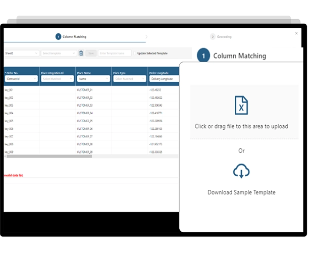
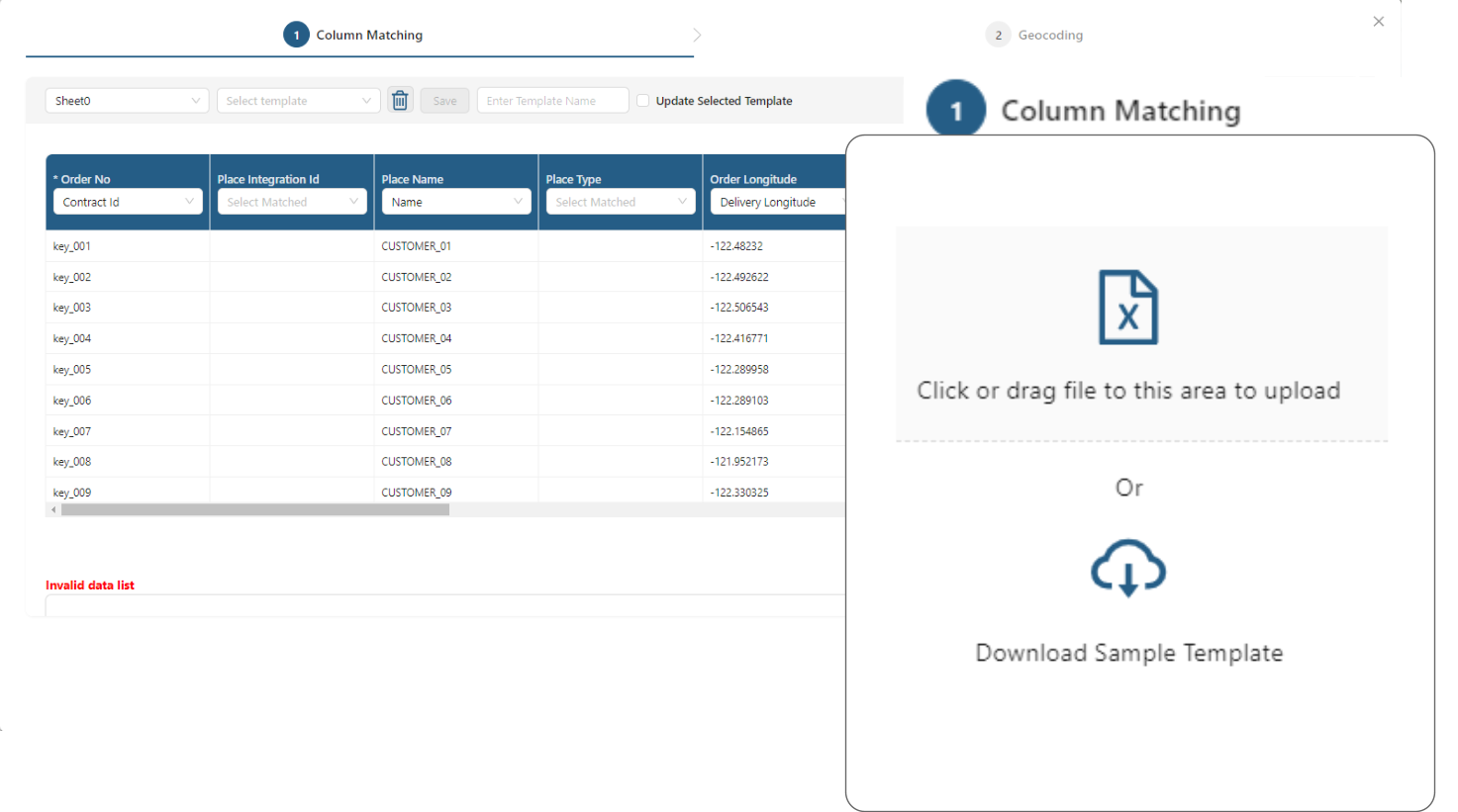
- Bulk Import: Utilize the data import feature to transfer all orders from your Excel sheets to DynaRoute.
- Column Alignment: Manually match your columns with the relevant columns in DynaRoute using drop-down menus and set this as the default for future imports. Click “Continue” to review and verify column matches for accuracy and formatting. The column names in your file do not need to exactly match those in DynaRoute, but proper correspondence must be established. Columns you choose not to import can be marked as ‘Not Matched’. Once all orders are correctly mapped, click “Save” to complete the import process.
- Error Notifications: The program will alert you to any matching errors or format issues, providing examples of the correct format.
- Real-Time Tracking: Enable the Real-Time Order Tracking feature to allow customers to track their orders live.
Geocoding
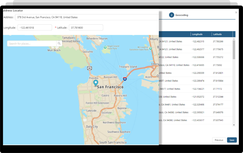
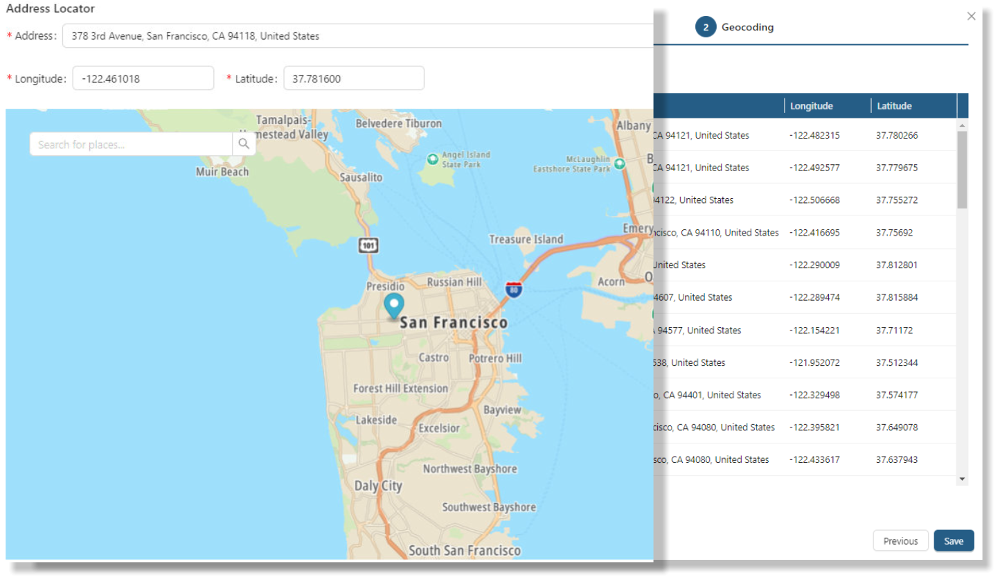
Accurate geocoding and verification of customer addresses are essential for efficient route planning.
- Data Improvement: DynaRoute, developed with advanced AI-powered geocoding algorithms, helps prevent errors in address and coordinate data. These algorithms help create a clean data set for addresses by removing unnecessary details (such as floor numbers or building names) and focus on geocoding using the street name, location, or postal code.
- Enhanced Accuracy: DynaRoute cross-references data with multiple coding methods and can process thousands of addresses simultaneously.
- If geocoding is not feasible, DynaRoute assists with manual data correction.
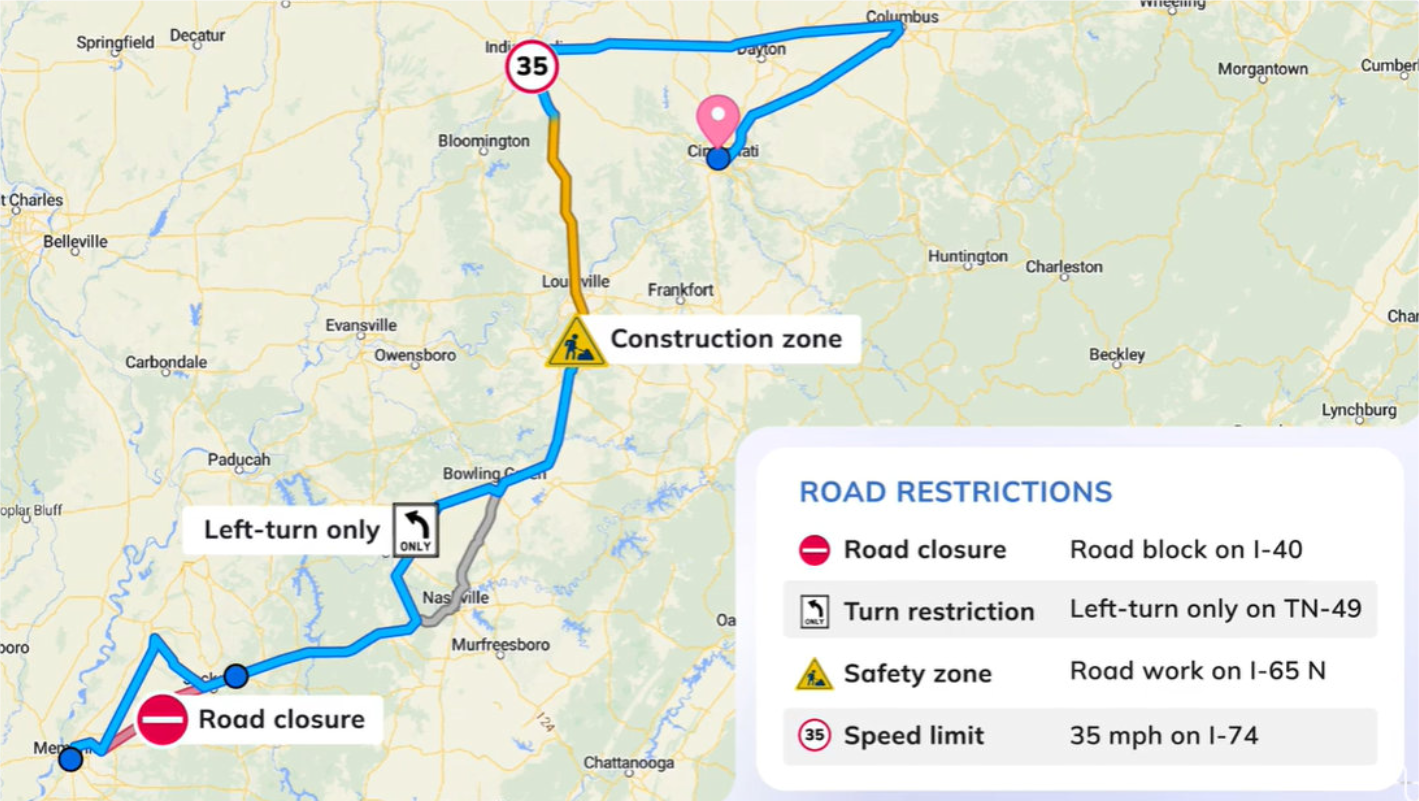
DynaRoute Road
Editor
Editor
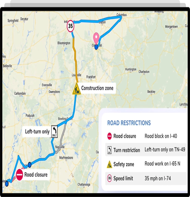
The DynaRoute Route Editor Tool addresses the challenge of accurately incorporating road closures, restrictions, speed limits, and permits into routing and navigation APIs. Fleet operators can utilize this tool to update fundamental road network data to reflect upcoming or recurring restrictions, which may vary by vehicle type, permits, time of day, and other relevant factors. By marking road closures as needed, operators can optimize route planning for fleets and real-time navigation for drivers. The Route Editor Tool enables businesses to precisely represent local road networks and regulations, offering options for road closures based on specific times of day or week, recurring frequencies, and/or vehicle types (cars, trucks, motorcycles, etc.). This functionality enhances operations such as deliveries, pick-ups, and drop-offs.
- Turn Restrictions: The Route Editor Tool allows users to optimize navigation algorithms to accommodate local turn restrictions and customize these settings from one region to another, ensuring safe and accurate real-time navigation that reflects regional turn restrictions.
- No Parking Zones: Operators can designate no parking zones using the Road Editing Tool. Once designated, the navigation system will permit drivers to pass through these zones but will prevent them from starting or ending their journeys within these areas.
- Maximum Speeds and Fixed Speeds: The tool allows operators to set maximum and fixed speed limits on specific roads. The maximum speed is the highest speed permitted on the road, which is typically, but not always, the official speed limit. The fixed speed is the speed factored into the routing engine to provide accurate estimated times of arrival (ETAs).
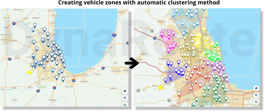
Smart Clustering
and Zoning 1
and Zoning 1
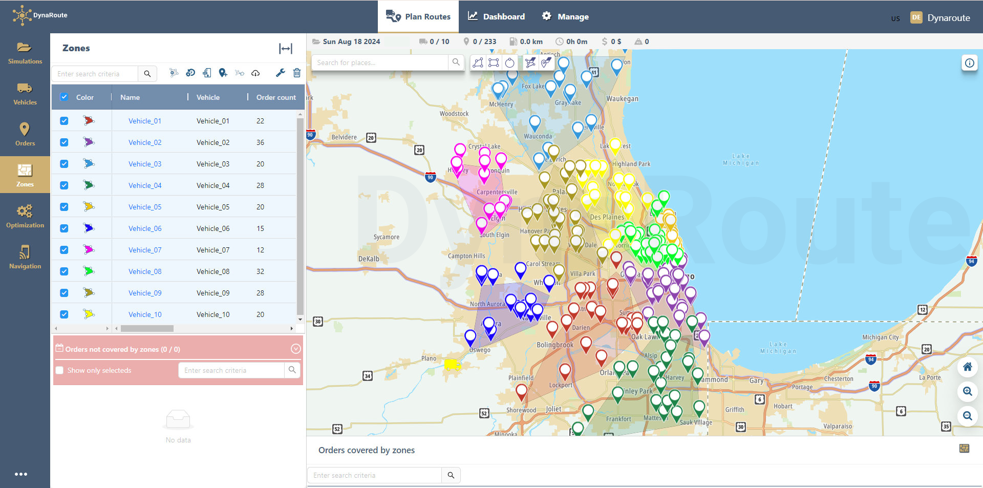
Improve zone planning through intelligent job clustering by considering factors such as driving distances, traffic patterns, highways, overpasses, drivers’ location preferences, and overlapping routes. DynaRoute offers various methods for zone creation:
- Manual Polygon Drawing: Create vehicle zones by interactively drawing polygons on the map around order locations using the polygon drawing tool. When defining these zones, order quantities (e.g., kg, m³, pieces, boxes, pallets) are considered, and any overcapacity is displayed interactively within the application. Zones can be imported from Excel files or ERP systems to generate an appropriate number of address clusters.
- KML Data Import: Import vehicle zones defined as polygons in KML format into the application. Users can then assign these predefined zones to vehicles and drivers.
Smart Clustering
and Zoning 2
and Zoning 2
- Order Location-Based Zones: Create vehicle zones based on order locations using the “assigned to vehicle” column in the location data. Vector polygons are generated for each vehicle and displayed on the map in different colors.
- Automatic Clustering Method: Vehicle zones are automatically generated within a few seconds using a honeycomb clustering approach. This method accounts for customer order quantities (e.g., kg, m³, pieces, boxes, pallets) and vehicle capacities. Users can define maximum and minimum capacity values or specify the number of vehicle zones to be created. The automatic clustering algorithm divides all customer addresses from Excel files or ERP systems into the most appropriate number of address clusters, with zones represented as vector polygons in various colors and symbologies.
Customized Route Optimization
and Visualization
and Visualization
Optimize routes based on predefined vehicle zones. Customer visit sequences within these vehicle zones, created using various methods (automatic clustering, manual drawing, KML import, or assignment to vehicles), are optimized for efficiency. Vehicle routes are displayed on the map with distinct colors and symbologies, and directional arrows indicate the routes followed by the vehicles.
Optimizing Routes for Efficiency
and Balance
and Balance
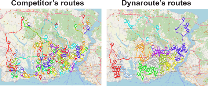
A common issue with many route optimization software solutions is the creation of inefficient, confusing, and unbalanced routes. Routes displayed in various colors and symbols can indicate overlapping or interfering services. DynaRoute addresses these problems by providing clean, well-clustered routes without intersections, which enhances driver satisfaction and reduces errors. Whether using clustered or free optimization, DynaRoute ensures consistently efficient, profitable, and operational routes.
Key features include:
- AI-Powered Optimization: Integrates drivers’ experiences into advanced algorithms for optimal routing.
- Customizable Adjustments: Allows route adjustments based on working hours, number of stops, or stop capacities. For example, you can configure the system to have all vehicles return at the same time in the evening or distribute packages evenly, leading to balanced routes and equitable shifts for drivers.
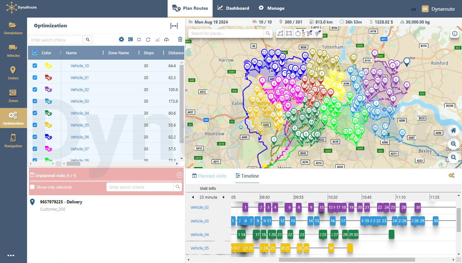
Drag & Drop
- The optimization tool features a drag-and-drop function that allows for flexible management of orders and routes.
- Orders on the map can be interactively selected using the selection polygon and then dragged and dropped to the most suitable location, either on the timeline or within the vehicle routes.
- Locations within vehicle routes, identified by different colors and symbols, can be selected using the “select by polygon” method on the map. These locations can then be removed from the route and dragged to the unplanned orders section if desired.
- Locations in the unplanned orders section can be marked with the cursor and then dragged and dropped to the most appropriate visit order, either on the vehicle routes on the map or within the vehicle routes list.
- The visit order within vehicle routes on the timeline can be adjusted. Users can change the visit order between different vehicle routes by using the drag-and-drop method or send planned order visits back to the unplanned orders window.
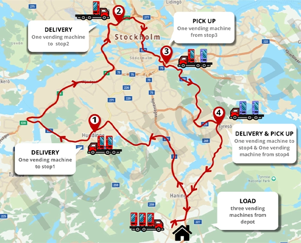
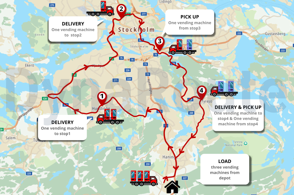
Pickup, Delivery and Shipment
- Integrated Operations: DynaRoute allows for the execution of both pickup and delivery operations within a single route plan.A real-life example might involve delivering new beverage coolers to a customer, picking up a malfunctioning machine from the same location, and transporting it to a repair facility at a different site. Another example of a planned and executed operation could be collecting students from their homes in the morning, dropping them off at school, and returning them home in the afternoon. The fully automated and optimized hybrid workflow enables the integration of pickups, deliveries, and returns within the same planned route
- Flexible Order Management: Easily create pickup and delivery options for both new and existing orders.
- Simultaneous Operations: DynaRoute efficiently schedules pickups and deliveries at the same location and can also manage delivery to a third address within the same route.
- Vehicle Capacity Management: The system ensures that drivers have sufficient space to handle all pickups and drop-offs at each stop, optimizing vehicle capacity. DynaRoute takes into account the quantity of goods and vehicle capacities to streamline pickup, delivery, and shipment operations at a single location.
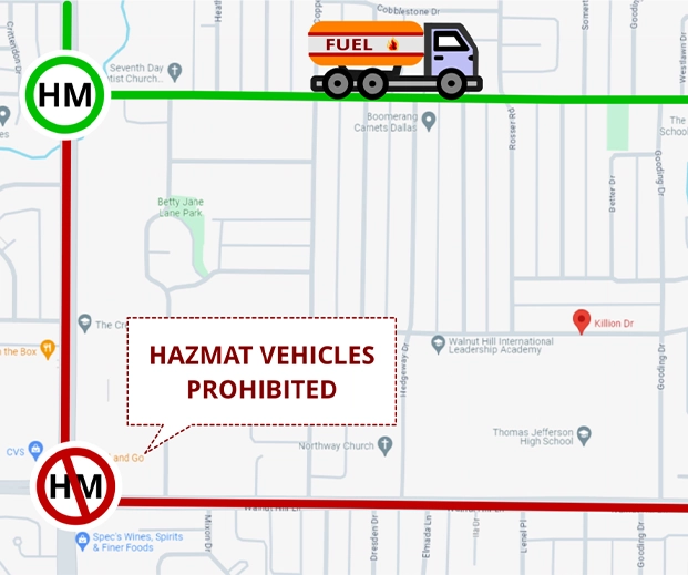
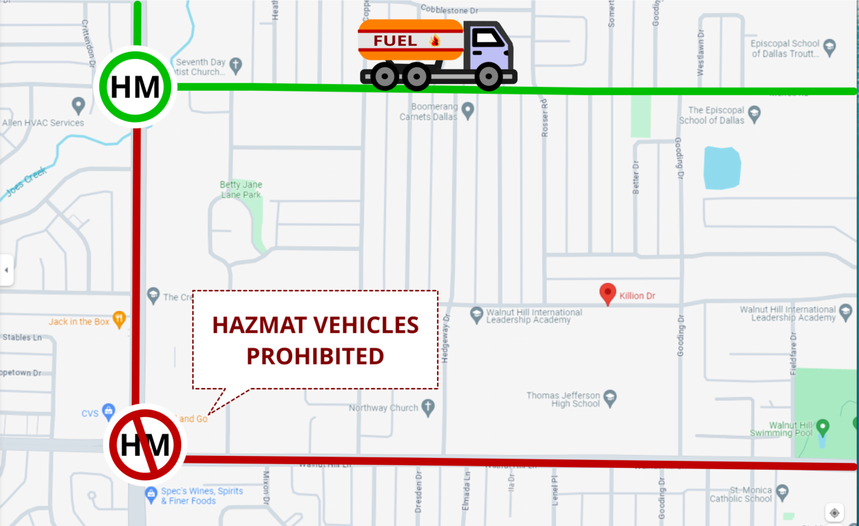
Safe Transportation of Dangerous Goods
DynaRoute’s groundbreaking dangerous goods transportation optimization feature allows you to transport hazardous materials in the safest and most efficient manner, avoiding penalties by taking into account safety issues, regulations, and road restrictions. This feature minimizes safety risks, protecting your drivers, vehicles, and cargo, and reduces the potential impact on your company’s safety record. DynaRoute utilizes a constantly updated digital vector map and the program calculates the safest and most suitable route considering all restrictions, vehicle characteristics, and live traffic conditions. The dispatcher can also use the RouteCell route editor feature to ensure that transportation is conducted in the most risk-free and cost-effective manner. For example, in the event of a sudden accident, fire, or other hazards on the route of a vehicle carrying radioactive or other flammable, explosive materials, the dispatcher can use this feature to direct the driver to an alternative route that is safer and less risky.
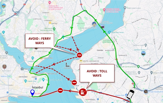
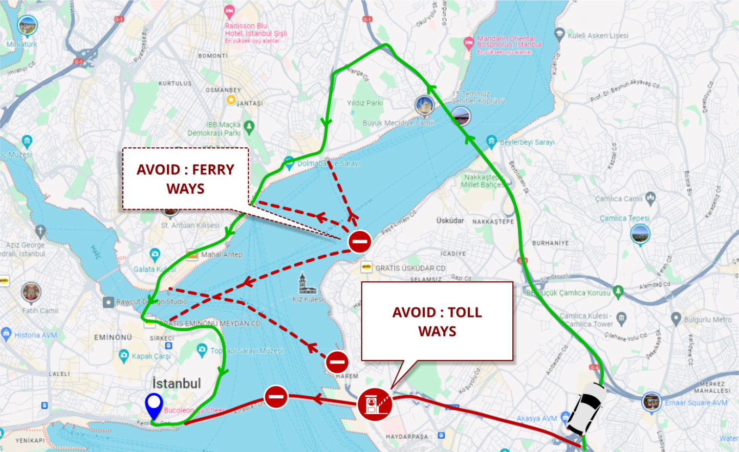
Customizable Avoidance Zones & Ways
When planning your routes, there may be specific areas and places you wish to avoid, such as ferry waterways, toll roads, or markets during holidays. DynaRoute’s route optimization software allows you to create custom-shaped Avoid Zones that can be easily activated when planning your routes. By using DynaRoute’s Route Optimization with Avoid Zones feature, you can significantly enhance the overall efficiency and safety of your route planning activities, ensuring that your drivers avoid unwanted areas and never pass through locations or regions that you wish to exclude.
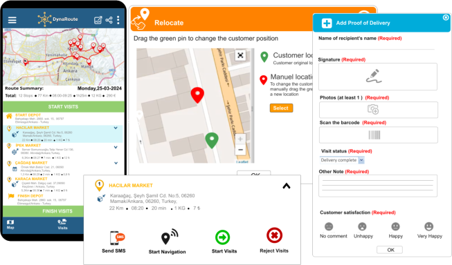
DynaRoute Mobile App for Drivers
DynaRoute Mobile is an application designed for field personnel to enhance the effectiveness of customer visits. It integrates seamlessly with DynaRoute’s web-based vehicle routing optimization software. Available for download on both Android and iOS devices, the app enables drivers to view customer visit sequences and timings and utilize its navigation feature to reach customers efficiently. Prior to each visit, the customer receives information on the exact delivery time via their mobile phone.
- Proof of Delivery (POD): Enter delivery times, obtain customer signatures, take photos of delivered goods and collect customer feedback. Use the barcode scanner and document reasons for non-delivery situations.
- Live Tracking: Continuously updates arrival times in real-time and provides route planners and customer service teams with detailed, up-to-date road condition insights. Enables prompt adjustments as needed and enhances visit efficiency and customer satisfaction by updating estimated arrival times and tracking driver and customer timings on the digital base map.
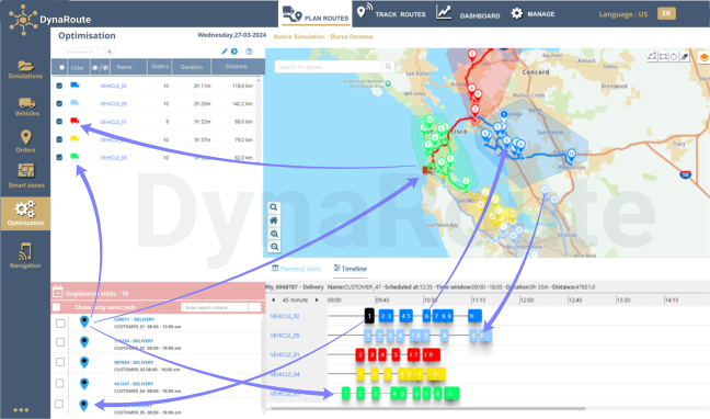
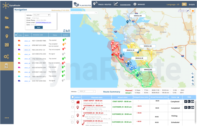
Field Performance Monitoring
Utilize DynaRoute’s live tracking feature to connect with GPS receivers and mobile devices, enabling real-time control and monitoring of your routes. When planning a route with DynaRoute, you can estimate arrival times for each service, compare to real arrival times by using different colors and symbols, and access detailed calculations such as distances covered, fuel consumption, costs, and journey durations. This feature allows adjustments for any delays and ensures that predetermined time windows for upcoming visits remain valid. The system also facilitates prompt re-routing if necessary. The feature provides constantly updated arrival times and live ETAs, offering route planners and customer service teams detailed, real-time insights into road conditions, enabling rapid responses to any issues. Significant deviations are reported to managers at regular intervals.
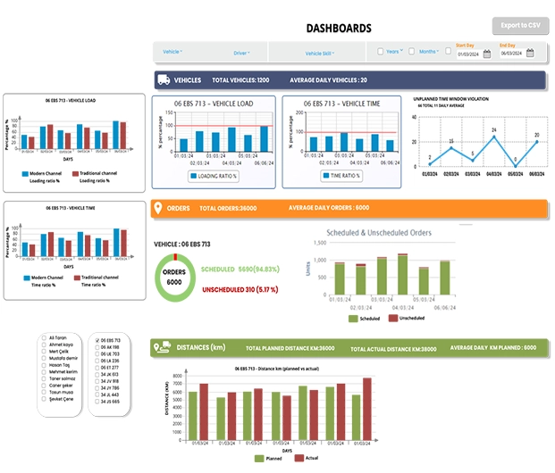
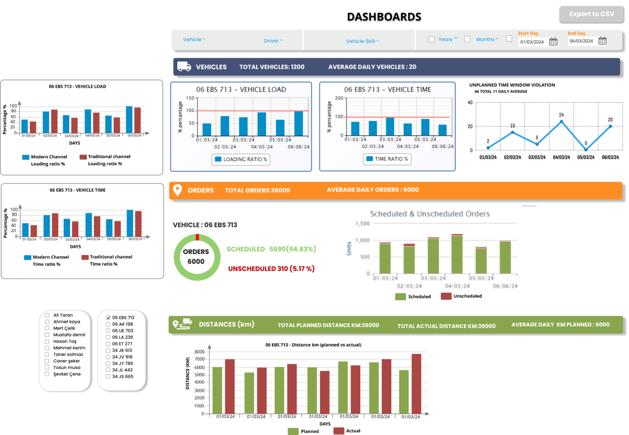
Dashboards & Reports
- Identify Cost-Saving Opportunities: Analyze data on distance traveled and time worked using color bar graphs, pie charts, and line charts. Assess vehicle or driver performance on a daily, weekly, monthly, or yearly basis. Easily determine and compare metrics such as distance traveled, fuel consumption, operating times, vehicle occupancy rates, and costs for different vehicles.
- Measure Order Performance: Evaluate both planned and unplanned orders. Display unfulfilled orders, returns, and ratios of planned to unplanned orders on graphs for any time interval. Compare distances planned by the system with actual distances traveled by the driver, with notifications for significant percentage differences.
- Generate Performance Reports: Send regular summary performance reports to administrator emails. Reports include details on distance traveled by each vehicle, arrival times, undelivered orders, cargo and costs per kilometer, and vehicle occupancy rates on routes.
Web Services API & INTEGRATION
Businesses can integrate with enterprise resource planning (ERP) platforms, order management systems (OMS), transportation management systems (TMS), or other third-party software using DynaRoute’s Web Service Application Programming Interface (API). Some of the platforms that DynaRoute integrates with include Microsoft Dynamics, SAP, Salesforce, Encompass TRchnologiRs, Oracle Fusion, Oracle NetSuite, Zoho, Zapier, Shopify, and Mark. The DynaRoute API is REST-based and uses the JSON (JavaScript Object Notation) format.

- Bulk Import: Utilize the data import feature to transfer all orders from your Excel sheets to DynaRoute.
- Column Alignment: Manually match your columns with the relevant columns in DynaRoute using drop-down menus and set this as the default for future imports. Click “Continue” to review and verify column matches for accuracy and formatting. The column names in your file do not need to exactly match those in DynaRoute, but proper correspondence must be established. Columns you choose not to import can be marked as ‘Not Matched’. Once all orders are correctly mapped, click “Save” to complete the import process.
- Error Notifications: The program will alert you to any matching errors or format issues, providing examples of the correct format.
- Real-Time Tracking: Enable the Real-Time Order Tracking feature to allow customers to track their orders live.
Geocoding
Accurate geocoding and verification of customer addresses are essential for efficient route planning.
- Data Improvement: DynaRoute, developed with advanced AI-powered geocoding algorithms, helps prevent errors in address and coordinate data. These algorithms help create a clean data set for addresses by removing unnecessary details (such as floor numbers or building names) and focus on geocoding using the street name, location, or postal code.
- Enhanced Accuracy: DynaRoute cross-references data with multiple coding methods and can process thousands of addresses simultaneously.
- If geocoding is not feasible, DynaRoute assists with manual data correction.
Road Editor
The DynaRoute Route Editor Tool addresses the challenge of accurately incorporating road closures, restrictions, speed limits, and permits into routing and navigation APIs. Fleet operators can utilize this tool to update fundamental road network data to reflect upcoming or recurring restrictions, which may vary by vehicle type, permits, time of day, and other relevant factors. By marking road closures as needed, operators can optimize route planning for fleets and real-time navigation for drivers. The Route Editor Tool enables businesses to precisely represent local road networks and regulations, offering options for road closures based on specific times of day or week, recurring frequencies, and/or vehicle types (cars, trucks, motorcycles, etc.). This functionality enhances operations such as deliveries, pick-ups, and drop-offs.
- Turn Restrictions: The Route Editor Tool allows users to optimize navigation algorithms to accommodate local turn restrictions and customize these settings from one region to another, ensuring safe and accurate real-time navigation that reflects regional turn restrictions.
- No Parking Zones: Operators can designate no parking zones using the Road Editing Tool. Once designated, the navigation system will permit drivers to pass through these zones but will prevent them from starting or ending their journeys within these areas.
- Maximum Speeds and Fixed Speeds: The tool allows operators to set maximum and fixed speed limits on specific roads. The maximum speed is the highest speed permitted on the road, which is typically, but not always, the official speed limit. The fixed speed is the speed factored into the routing engine to provide accurate estimated times of arrival (ETAs).
Smart Clustering & Zones (1)
Improve zone planning through intelligent job clustering by considering factors such as driving distances, traffic patterns, highways, overpasses, drivers’ location preferences, and overlapping routes. DynaRoute offers various methods for zone creation:
- Manual Polygon Drawing: Create vehicle zones by interactively drawing polygons on the map around order locations using the polygon drawing tool. When defining these zones, order quantities (e.g., kg, m³, pieces, boxes, pallets) are considered, and any overcapacity is displayed interactively within the application. Zones can be imported from Excel files or ERP systems to generate an appropriate number of address clusters.
- KML Data Import: Import vehicle zones defined as polygons in KML format into the application. Users can then assign these predefined zones to vehicles and drivers.
Smart Clustering & Zones (2)
- Order Location-Based Zones: Create vehicle zones based on order locations using the “assigned to vehicle” column in the location data. Vector polygons are generated for each vehicle and displayed on the map in different colors.
- Automatic Clustering Method: Vehicle zones are automatically generated within a few seconds using a honeycomb clustering approach. This method accounts for customer order quantities (e.g., kg, m³, pieces, boxes, pallets) and vehicle capacities. Users can define maximum and minimum capacity values or specify the number of vehicle zones to be created. The automatic clustering algorithm divides all customer addresses from Excel files or ERP systems into the most appropriate number of address clusters, with zones represented as vector polygons in various colors and symbologies.
Customized Route Optimization and Visualization
Optimize routes based on predefined vehicle zones. Customer visit sequences within these vehicle zones, created using various methods (automatic clustering, manual drawing, KML import, or assignment to vehicles), are optimized for efficiency. Vehicle routes are displayed on the map with distinct colors and symbologies, and directional arrows indicate the routes followed by the vehicles.

Optimizing Routes for Efficiency and Balance
A common issue with many route optimization software solutions is the creation of inefficient, confusing, and unbalanced routes. Routes displayed in various colors and symbols can indicate overlapping or interfering services. DynaRoute addresses these problems by providing clean, well-clustered routes without intersections, which enhances driver satisfaction and reduces errors. Whether using clustered or free optimization, DynaRoute ensures consistently efficient, profitable, and operational routes.
Key features include:
- AI-Powered Optimization: Integrates drivers’ experiences into advanced algorithms for optimal routing.
- Customizable Adjustments: Allows route adjustments based on working hours, number of stops, or stop capacities. For example, you can configure the system to have all vehicles return at the same time in the evening or distribute packages evenly, leading to balanced routes and equitable shifts for drivers.
Drag&Drop
- The optimization tool features a drag-and-drop function that allows for flexible management of orders and routes.
- Orders on the map can be interactively selected using the selection polygon and then dragged and dropped to the most suitable location, either on the timeline or within the vehicle routes.
- Locations within vehicle routes, identified by different colors and symbols, can be selected using the “select by polygon” method on the map. These locations can then be removed from the route and dragged to the unplanned orders section if desired.
- Locations in the unplanned orders section can be marked with the cursor and then dragged and dropped to the most appropriate visit order, either on the vehicle routes on the map or within the vehicle routes list.
- The visit order within vehicle routes on the timeline can be adjusted. Users can change the visit order between different vehicle routes by using the drag-and-drop method or send planned order visits back to the unplanned orders window.
Pickup, Delivery and Shipment
- Integrated Operations: DynaRoute allows for the execution of both pickup and delivery operations within a single route plan.A real-life example might involve delivering new beverage coolers to a customer, picking up a malfunctioning machine from the same location, and transporting it to a repair facility at a different site. Another example of a planned and executed operation could be collecting students from their homes in the morning, dropping them off at school, and returning them home in the afternoon. The fully automated and optimized hybrid workflow enables the integration of pickups, deliveries, and returns within the same planned route.
- Flexible Order Management: Easily create pickup and delivery options for both new and existing orders.
- Simultaneous Operations: DynaRoute efficiently schedules pickups and deliveries at the same location and can also manage delivery to a third address within the same route.
- Vehicle Capacity Management: The system ensures that drivers have sufficient space to handle all pickups and drop-offs at each stop, optimizing vehicle capacity. DynaRoute takes into account the quantity of goods and vehicle capacities to streamline pickup, delivery, and shipment operations at a single location.
Safe Transportation of Dangerous Goods
DynaRoute’s groundbreaking dangerous goods transportation optimization feature allows you to transport hazardous materials in the safest and most efficient manner, avoiding penalties by taking into account safety issues, regulations, and road restrictions. This feature minimizes safety risks, protecting your drivers, vehicles, and cargo, and reduces the potential impact on your company’s safety record. DynaRoute utilizes a constantly updated digital vector map and the program calculates the safest and most suitable route considering all restrictions, vehicle characteristics, and live traffic conditions. The dispatcher can also use the RouteCell route editor feature to ensure that transportation is conducted in the most risk-free and cost-effective manner. For example, in the event of a sudden accident, fire, or other hazards on the route of a vehicle carrying radioactive or other flammable, explosive materials, the dispatcher can use this feature to direct the driver to an alternative route that is safer and less risky.
Customizable Avoidance Zones & Ways
DynaRoute’s groundbreaking dangerous goods transportation optimization feature allows you to transport hazardous materials in the safest and most efficient manner, avoiding penalties by taking into account safety issues, regulations, and road restrictions. This feature minimizes safety risks, protecting your drivers, vehicles, and cargo, and reduces the potential impact on your company’s safety record. DynaRoute utilizes a constantly updated digital vector map and the program calculates the safest and most suitable route considering all restrictions, vehicle characteristics, and live traffic conditions. The dispatcher can also use the RouteCell route editor feature to ensure that transportation is conducted in the most risk-free and cost-effective manner. For example, in the event of a sudden accident, fire, or other hazards on the route of a vehicle carrying radioactive or other flammable, explosive materials, the dispatcher can use this feature to direct the driver to an alternative route that is safer and less risky.
DynaRoute Mobile App for Drivers
DynaRoute Mobile is an application designed for field personnel to enhance the effectiveness of customer visits. It integrates seamlessly with DynaRoute’s web-based vehicle routing optimization software. Available for download on both Android and iOS devices, the app enables drivers to view customer visit sequences and timings and utilize its navigation feature to reach customers efficiently. Prior to each visit, the customer receives information on the exact delivery time via their mobile phone.
The application includes a Proof of Delivery (POD) feature, allowing drivers to enter delivery times, obtain customer signatures, take photos of delivered goods, collect customer feedback, use the barcode scanner, and document any reasons for non-delivery. Additionally, DynaRoute Mobile offers a Live Tracking feature, continuously updating arrival times in real-time. This functionality provides route planners and customer service teams with detailed, up-to-date insights into road conditions and allows for prompt adjustments if needed. Real-time visit data from DynaRoute Mobile enhances visit efficiency and customer satisfaction by constantly updating estimated arrival times and tracking driver locations, as well as customer arrival and departure times on the digital base map.
Field Performance Monitoring
Utilize DynaRoute’s live tracking feature to connect with GPS receivers and mobile devices, enabling real-time control and monitoring of your routes. When planning a route with DynaRoute, you can estimate arrival times for each service, compare to real arrival times by using different colors and symbols, and access detailed calculations such as distances covered, fuel consumption, costs, and journey durations. This feature allows adjustments for any delays and ensures that predetermined time windows for upcoming visits remain valid. The system also facilitates prompt re-routing if necessary. The feature provides constantly updated arrival times and live ETAs, offering route planners and customer service teams detailed, real-time insights into road conditions, enabling rapid responses to any issues. Significant deviations are reported to managers at regular intervals.
Dashboards & Reports
- Identify Cost-Saving Opportunities: Analyze data on distance traveled and time worked using color bar graphs, pie charts, and line charts. Assess vehicle or driver performance on a daily, weekly, monthly, or yearly basis. Easily determine and compare metrics such as distance traveled, fuel consumption, operating times, vehicle occupancy rates, and costs for different vehicles.
- Measure Order Performance: Evaluate both planned and unplanned orders. Display unfulfilled orders, returns, and ratios of planned to unplanned orders on graphs for any time interval. Compare distances planned by the system with actual distances traveled by the driver, with notifications for significant percentage differences.
- Generate Performance Reports: Send regular summary performance reports to administrator emails. Reports include details on distance traveled by each vehicle, arrival times, undelivered orders, cargo and costs per kilometer, and vehicle occupancy rates on routes.
Web Services API & INTEGRATION
Businesses can integrate with enterprise resource planning (ERP) platforms, order management systems (OMS), transportation management systems (TMS), or other third-party software using DynaRoute’s Web Service Application Programming Interface (API). Some of the platforms that DynaRoute integrates with include Microsoft Dynamics, SAP, Salesforce, Encompass TRchnologiRs, Oracle Fusion, Oracle NetSuite, Zoho, Zapier, Shopify, and Mark. The DynaRoute API is REST-based and uses the JSON (JavaScript Object Notation) format.